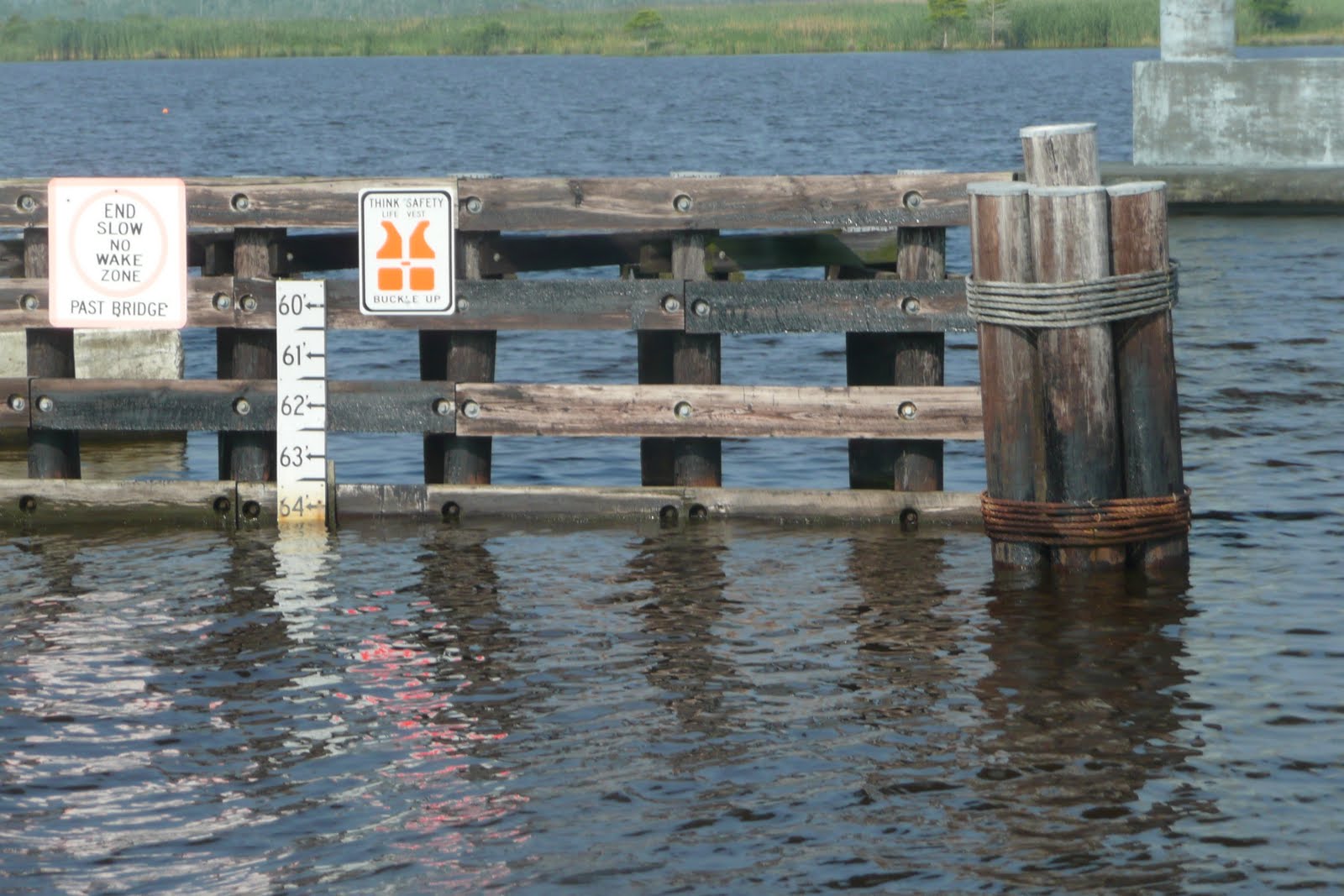




We left Beaufort at 6 AM originally planning to go through the nearby bascule bridge at 6:30, their last opening before the rush hour traffic period. But a second look at the charts showed some thin water in the Russell Slough channel beyond and it was dead low tide. So we took the longer route around and under the fixed bridge. These have a "guarenteed" clearence of 65' and maybe that was true when they were designed. Our mast is 63' high so this is definitely a cause of concern! Some bridges however have less than that at high tides or wind. Many bridges have a the clearance posted on the bulkhead boards (see photos of these boards and our mast looking up at the underside of a bridge). Once years ago we heard our antenna tap it's way through a set of twin bridges - pretty scary moments!
Our first trip down the intercoastal six years ago we went the whole way inside to Ft. Lauderdale (between that and Miami there's a fixed bridge with a lower clearence). We had a chart book of the Intracoastal that friends had annotated showing questionable bridges and shallow water problems. We have a draft of 6.5 feet and there are depths of 3 feet at low tide at troubled spots. At mid tide or better, hopefully rising, these are manageable. Unfortunately we gave that book away years ago with the promise it would be returned (it hasn't).
When we were in Georgia we thought we might be taking the inner route north for awhile, and spent a lot of time checking the Corps of Engineers published reports and notes from the Waterway guides & other cruisers. These were all transfered to our current (found in a book exchange for free but years old) chart book along with bridge opening times.
That's another reality and problem on the Intracoastal. There are a lot of opening briges although they are being replaced by fixed ones gradually. This coming section of the ICW from Beaufort to Norfork has five of them and a lock. Timing for these is critical as each has different opening schedules and you attempt to time your trip between them to arrive at the right moment. And then there is the traffic - in both directions. Motor boats of all sizes and barges pass all the time. Since they throw a wake that in the narrow channel can cause havoc on your boat, polite passing is an art. The overtaking boat in either direction calls on the VHF to inform the passee on which side they will be and usually suggesting they can make it a "slow pass" if desired. This means that they will slow down a lot and generally the sailboat offers to slow down as well, making the process over quicker. Frankly this gets tiring and we usually just say, thanks but just head on past. We're a heavy boat and therefore harder to rock. Our VHF is busy all day long with these conversations and unfortunately with angry people responding to speeding silent motor boats who throw wakes without any warning at passing boats and even those tied up on the sides. You can follow the progress of these offenders as they head south or north by the string of #$%*&s!
We don't travel at motor boat speeds but we often exceed the average sailboat rate. This means either passing them or falling in line. In the first two days we passed many, but eventually by the last day came to a line of five sailboats and slowed down to form the caboose. Traveling in the ICW takes focus. The channel can wind torturously in rivers or steams, straight ahead in narrow canals, or in all directions on the great Sounds, like the Pamlico and Albermarle we had ahead of us. These are confusing as sometimes it looks like you're on the ocean and yet twenty feet away there is only 3 feet of mud.
Many people, Scott included, find the combination of necessary focus and often routine scenery very boring. He is not fond of hand steering and in fact prefers not to touch the wheel. He uses the electronic method; his finger on a button. Mega yachts prefer a joy stick. I really don't mind. It's like one of my puzzles - there's the charts, guide book, markers, schedules and they all have to fit together. Satisfying! Plus I find the scenery interesting. To do this you have to enjoy the patterns in the water and sky, as well as the birds (there are osprey nest of almost every ICW marker), occasional houses, and of course, lots of marshes.
Our first day dolphins welcomed us back on the water. It was 9.5 hours of motoring to our first anchorage in Bel Haven. We're using Skipper Bob's Anchorage Guide for the first time so went further past the town and nearer the bridge. We left the boat years ago in Bel Haven for a month so we are familiar with the town - a quiet neat place that feels very old fashioned. Without the modern cars you'd think you were back in the 50's. We took a long walk in the morning - great hardware store right downtown! Like many communities they have had a fund raiser with artists decorating a town mascot, in this case a crab! The charming local museum (above left) has many fun oddities as well.
The second day was shorter, only 4.5 hours to our next anchorage at Tuckahoe Point. This is a short shallow trip off the ICW with not a house in sight, but near an air force base as all three times we've anchored there, we've been treated (?) to a few jet formation passes as we drink our sundowners. Scott jumped in the water with his weight belt to scrub the water line. He'd hoped to clean the prop but the water was so dark (not muddy but brown colored) he couldn't see his hand, let alone the prop.
We were off early the next morning as we had the Alligator River and the Ablemarle Sound to cross before our next stop in Coinjock. The wind was increasing during the day and these shallow waters can get really choppy. Happily we had enough wind to sail for a good portion of the time but not enough to make it uncomfortable. We passed "Janus" during the morning and at Judy's suggestion over the VHF, took each other's picture which we exchanged later at the marina over dinner. That's Bill and Judy shown here.
There are two marinas in Coinjock across from each other in the canal, Coinjock and Midway. We stayed at the former this time but have visited both. Strangely Coinjock was packed with boats but few were at Midway. Perhaps it's the popular restaurant and the Thursday night prime rib special (excellent, that's the outside seating shown here).
It was another early morning, leaving at 6 AM, as we had a lot of bridges and a lock to go through today. It's only 50 miles to Norfork but it took us eleven hours. Mist hung over the river and it was possible to look straight at the sun for over an hour after it appeared the (picture here). We were able to sail for hours on the North Landing River. As I mentioned before we caught up to a line of four sailboats and took up the rear position as we approached our first bridge. We could have made it to the next bridge in a half hour but the other boats couldn't, so rather than pass four sailboats, we just dawdled along for an hour. After that came the lock. This is the only one we've ever been in and real easy as there is no turbulence and lots of room to tie up to the sides. My photos show us tied up at the lock side and the doors closing behind us.
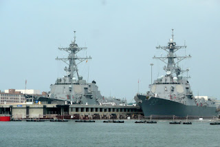
The Steel bridge follows next and then a railroad bridge, which is usually open. It wasn't this time and we waited 45 minutes without knowing when or if it would open. Strangely enough the next railroad bridge was also closed. Construction workers were evident but no information. However we suddenly had info on the previous bridge - it was now closed and not expected to open again that day. Poor boats behind us!!! We were starting to make plans for an anchorage site right there for the night when our bridge finally opened and let us out of the ICW. We were in Norfork at the mouth of Chesapeake Bay. This is a big change from anything we've experienced since we last passed through here. The enormous Naval base stretches along both sides of the huge harbor with hundreds of warships of all kinds.
Our original plans were to anchor near Hospital Point just out of the channel where years before we watched Fourth of July fireworks, but as it was a beautiful day, we decided to cross over to Hampton instead. We've never been there but our guide recommended an anchorage there right in the center of town. We won't be suggesting that to others though. It's a very small shallow area and full of crab pots. It is lovely however with Hampton University on one side of the river and the attractive waterfront on the other. Several marinas are available and if we had more time, we'd tie up there and explore the area.
The next day, after reversing off the mud flats at our anchorage, was a long sail up the west side of the bay to Deltaville. On the way we passed this lovely isolated light house, one of many of this type on the Chesapeake. We had planned to anchor in Fishing Bay south of the town but after listening to the weather report we decided to A. take a day off and B. chose a safer, protected anchorage. Possible severe thunderstorms were predicted for tomorrow. So we wended our way into Jackson Creek at Deltaville through the narrow circuitous channel that comes perilously close to the beach. We've done this several times so it's not quite as scary and since the first time, haven't bounced off the bottom! Once inside it's a lovely place, but with a soft mud bottom, a bit difficult to set the anchor. After four !!! tries we had it down.
Deltaville Marina is a great place and so welcoming. For $10 a day each we could use all their facilities. They have an air conditioned lounge, a pool, good laundry machines, bicycles, and they let you use their car for an hour!
We walked into town in the morning for breakfast and some shopping but later in the day Scott used the car to do some boat supply browsing at the two West Marines. Happily we made friends with Gerry and Bear on "Bear Holiday" and had drinks on their boat that night. We discovered a lot in commen. Gerry worked at New England Telephone with me, but in Maine and Bear taught skiing at Jiminy Peak and Sunapee. As our time with them drew to a close the sky turned dark and ominous. We rushed out to the boat as the rain began and a big gust of wind hit. A catamarin in front of us dragged on their anchor through the other boats and landed on a sand bar. Other cruisers turned on their engines and stood at their wheels ready to take action. Some reanchored in more spacious spots. Dinghies from the marina rushed out to pull the catamarin off the bar and reanchor. And the skies opened! All the excitement was over in an hour and after a change of clothes we warmed up with some hearty lentil soup.
We were off early in the morning heading north to the Potomac. A single handed sailor in front of us had a lot of problems in the narrow channel and after three tries he came out and asked to follow us. A helpful experienced local sailor chimed in on the VHF with some advice which we followed successfully. We looked back to see if the fellow was behind and found he'd come aground again before even entering the channel! And he had only 5 feet draft! Happily he was able to finally make his way out.
It was a beautiful morning and we were under sail again and headed for our long awaited visit to Washington D.C.