 |
| Grayson State Park where we stopped for lunch and a hike on our way to the New River National Park |
 |
| The view from the beginning of the Fayetteville Station Road of the New River, looking away from the bridge. |
We spent four nights in West Virginia before moving on to Washington DC and it was a fascinating history lesson. This is a beautiful state with a rich history that we knew little of. We visited the New River Gorge National Park and then Blackwater Falls State Park. Both were centers of coal and coke production from the 1860s to the 1950s. There were remnants of mining operations and whole towns that no longer exist.
For the first two nights we stayed at the very nice Rifrafters RV Park. Our site was spaced well away from others with a good view. The owners came over and chatted with us for some time. It was only a few miles from the main Visitor's Center at the north end of the National Park, which was only redesignated from being a National River in 2020. It is 53 miles long but not that wide as it follows the river. That river exposed four seams of coal, considered among the best bituminous coal in the world. That smokeless coal once fed the boilers of the nation's trains, factories, fleets and power plants, and the coke made from it fueled the nation's iron furnaces. But that mining process and industries tore up the land and polluted the waters and air. It provided jobs for thousands but ruined their health and their families'. The coming of the railroad in 1873 opened up the region and it is still in constant use by Amtrak.
 |
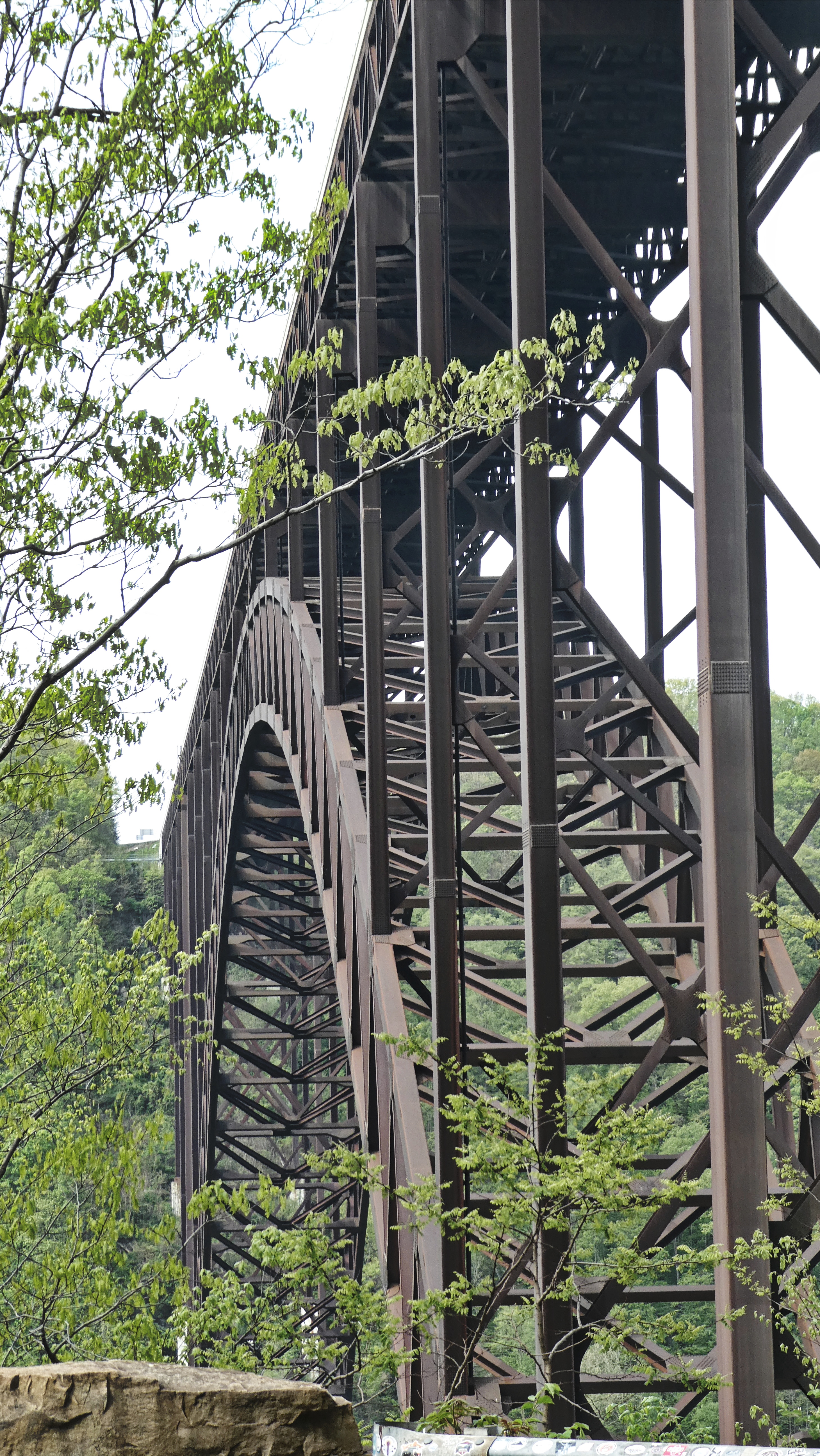
| The bridge down at the bottom of the gorge at Fayette Station |
We were able to visit three of the main sections of the Park. The one way now, but two way originally, Fayette Station road winds it's way down the cliffs on both sides of the river. It led to at first a ferry crossing, then a succession of bridges that were eventually destroyed by river flooding (a newer small bridge is there now), and finally made obsolete by the building of the longest single arch bridge at one time and now the longest outside of China. It was completed in 1977 and before then it was a long process to cross the river in this area. The road is narrow with hair pin turns and it took us almost an hour to go from one side of the river to the other. Now it can take minutes!
 |
| View of the bridge from halfway down the Fayette Station road. |
 |
| The New River Bridge from Fayette Station at the river level. |
 |
| The Thurman Amtrak Station |
 |
| That's the one way road at Thurman across the river on the left with a person on it. |
 |
| The Town of Thurman main street right along the railroad tracks. The homes were up the hill on winding roads. |
 |
| This was once a thriving town of several hundred and lots of business and hotels catering to the railroad. The 2020 census showed 5 residents. |
The entrance to the next area, Thurman, was 45 minutes south and was accessed by another narrow but paved road down to the river edge and then to an amazing bridge. A long one lane narrow road for cars goes along side the railroad tracks. We assumed it was one way and there was another way back - NO, that was almost the only way back (I'll tell you about the alternative we tried in the next paragraph). So you had to wait until the bridge was empty and go out quickly to establish the direction. Cars entering after you on the other side had to back up and get out of the way. Not easy! And then the parking lot on the Thurman side was small. We can't imagine how this all works in the busy season!
 |
| This shows how big the hotels were at Thurman - now all gone. This one burned down. |
 |
| After we emerged from our attempt at going down the east side of the river, Scott took this picture and enlarged it so we could read this warning! The town of Thayer is misleading - just a few houses left. |
But the abandoned town of Thurman has been "stabilized" and the railroad station is very active. Quite a few trains came and went while we were there. We had to wait quite a long time for one train to pass before we could return to our car. On the park map another road is shown going down the east side of the river about 40 miles to our next destination. It was clearly a small road but there was a town, Thayer, midway so we thought it wouldn't be a problem. Until we reached that "town" the road was very narrow with pull offs for cars to pass each other, but it was paved and there were fences or stones along the steep drop offs in most places. The "town" consisted of about 8 very dilapidated houses and the next section of the road had a sign, "Unimproved" and "Rough". It seemed such a long way to go back at that point so we started down it. The pavement ended and ruts and big pot holes appeared. It was very narrow. Now finally, we made the right decision. We carefully turned around and made the long journey back to the main road.
 |
| Grand View of the New River |
 |
| Looking south from Grand View |
 |
| Part of the Tunnel Trail at Grand View |
Once on the highway we proceeded down to the last section of the park, Grand View. This was a very popular State Park until it was incorporated into the National Park in 1990. It has trails, a theater, ball park, children's playground & picnic areas - and an amazing view of the river. We did a short hike on the Tunnel Trail and enjoyed the views. It was a long but delightful day exploring this beautiful National Park!
 |
| Heather at one of the viewpoints along the stairs that descend the Gorge at Blackwater Falls. |
 |
| Another view going down the Gorge. The last viewpoint is on the left of the falls. |
Next we drove east to Blackwater Falls State Park for two nights, staying right in the Campground there. Our daughter-in-laws family go there every year for vacation together, renting cottages in the park. There is a full service Lodge in the park, reminiscent of the National Parks out west, where we had a good dinner there one of the nights. The park is named for the 62-foot cascade which is amber colored due to its tannic-darkened water. A long series of rustic stairways descend into the gorge from the Visitor's Center providing lovely views and a good workout! We did this our first afternoon and then spent our full day exploring the area, including Lindy Point and Elakala Falls. After spending most of the day in the park itself we drove to see the Douglas Falls near the town of Thomas. The very rough unpaved road that led us down there from the town (we would have turned around but a truck came out from there and told us it was passable) goes to the abandoned town of Coketon, once a busy coke producing industry. One of the signs (lots of them detailing the history) says, "The last underground coal mine here closed in the early 1950's, leaving a legacy of acid mine drainage, abandoned industrial structures, coke ovens and debris". And lots of pollution!
 |
| A view of just one section of the stairway down to Blackwater Falls |
 |
| White Laurel was in bloom. There were huge numbers of rhododendron every where. It must be amazing when in bloom. |
 |
| One of the living rooms areas at the Lodge at Blackwater State Park. |
One fascinating piece of history - The Coketon Colored School was the center of a Civil Rights case in 1892. The teacher Carrie Williams and the first African American lawyer in West Virginia, J.R. Clifford, brought suit against the Board of Education, which finally went to the state Supreme Court and they won it. She had been ordered to shorten the school year for her students. It was the first civil rights case in the history of the U.S. to determine discrimination on the basis of color to be illegal.
 |
| The view from Lindy Point looking south. |
 |
| We both love the twisted limbs of trees. |
 |
| The trails around both parks were often lined with rhododendrons. |
 |
| The Company Store at Thomas, now an artist's cooperative gallery. |
 |
| Abandoned Coke furnaces. There were over 200 originally spuming smoke and gasses. |
 |
| A section on the river on our way to Douglas Falls. This river is still heavily polluted. |
 |
| There was a steep path down to the falls that looked wet and slippery so we skipped it. Not much of a view from the trail at the end of the road. |
 |
| That's a picture of Douglas back in the heyday of coal mining. The forest was all clear cut and it was a big town. Now the trees have grown back and only a few houses remain. |
But our time in West Virginia was over and we headed east again to Washington D.C. and then a week later we'll go back up to Vermont. That will be my next and last post on this trip.


No comments:
Post a Comment