 |
| The view from the Visitor's Center of the Glen Canyon Dam and Bridge |
 |
| Another view from further down the Lake Shore Drive looking back. The water level in Lake Powell is only just above the intake to the Power Plant. If it goes down any further, electricity production will cease. If it continued down, the River would run dry. |
Our next two days in Page were busy but more varied. Page was originally built as a company town for the construction of the Glen Canyon Dam. Chosen as the dam location on the Colorado after intense debate over locations for this second dam on the Colorado after Hoover Dam, it was originally far away from any recent civilization. It's a long Wikipedia article folks, but quite interesting.
 |
| Looking down the Colorado River from the bridge. |
 |
| Navajo Mountain rises up from the plain to 10,000 feet. |
The Visitor's Center is large and museum like with lots of information about the history, construction of the dam and the environment. It also provides a great view of the dam and the river. We walked over the bridge both ways to enjoy the views also. Then we drove down the Lake Shore Drive into National Glen Canyon Recreational Area, which contains the Wahweap Marina, RV Campground and the Lake Powell Resort. At this time of year the Marina appeared to be unused, and the hotel restaurants weren't open other than for hotel guests (not many) for dinner. But we liked the Wahweap RV Campground with a variety of hookups, and like the Lees Campground (both recreation.gov), we'll plan to return. On the way back we also stopped into the Beehive Campground on the other side of Route 98. It had no hookups and a tight configuration of 6 campsites so not as attractive.
 |
| The drive to the Navajo National Monument on Route 98 was very scenic with buttes and formations of all shapes and sizes. We loved this one but could only get a few photos as there weren't any pull offs on the road. |
 |
| The sandal trail down to the view point to see the Betatakin "House Built on a Ledge" pueblo. That's me in the distance, easily visible in my bright pink parka. It was cold and windy. We wished we had gloves and hats! |
The next day we went east, first to the Antelope Point to see the Marina there, the launching point, and the Campground. The campground was very nice but expensive at $70 per night - it's privately run unlike Lees and Wahweap. Then we stopped at the Antelope Lower Canyon Touring locations to check out the prices. At $70 a person for a 1.25 hour tour we decided it was too expensive (the Upper Canyon Tours are even more expensive). Maybe next year. We were off that day to the free and fascinating Navajo National Monument - about 1.5 hours away. The scenery was nice along the way and for a change, we were one of the very few people there! What a contrast to the Horseshoe Bend National Monument. Of course, it's a long way from anywhere. Again we had driven up hill the whole way, it's at 7,500+ hundred feet and there was lots of snow everywhere. The temperature was 32 degrees mid day.
 |
| Looking down the Canyon to the horizon near the end of the trail. |
 |
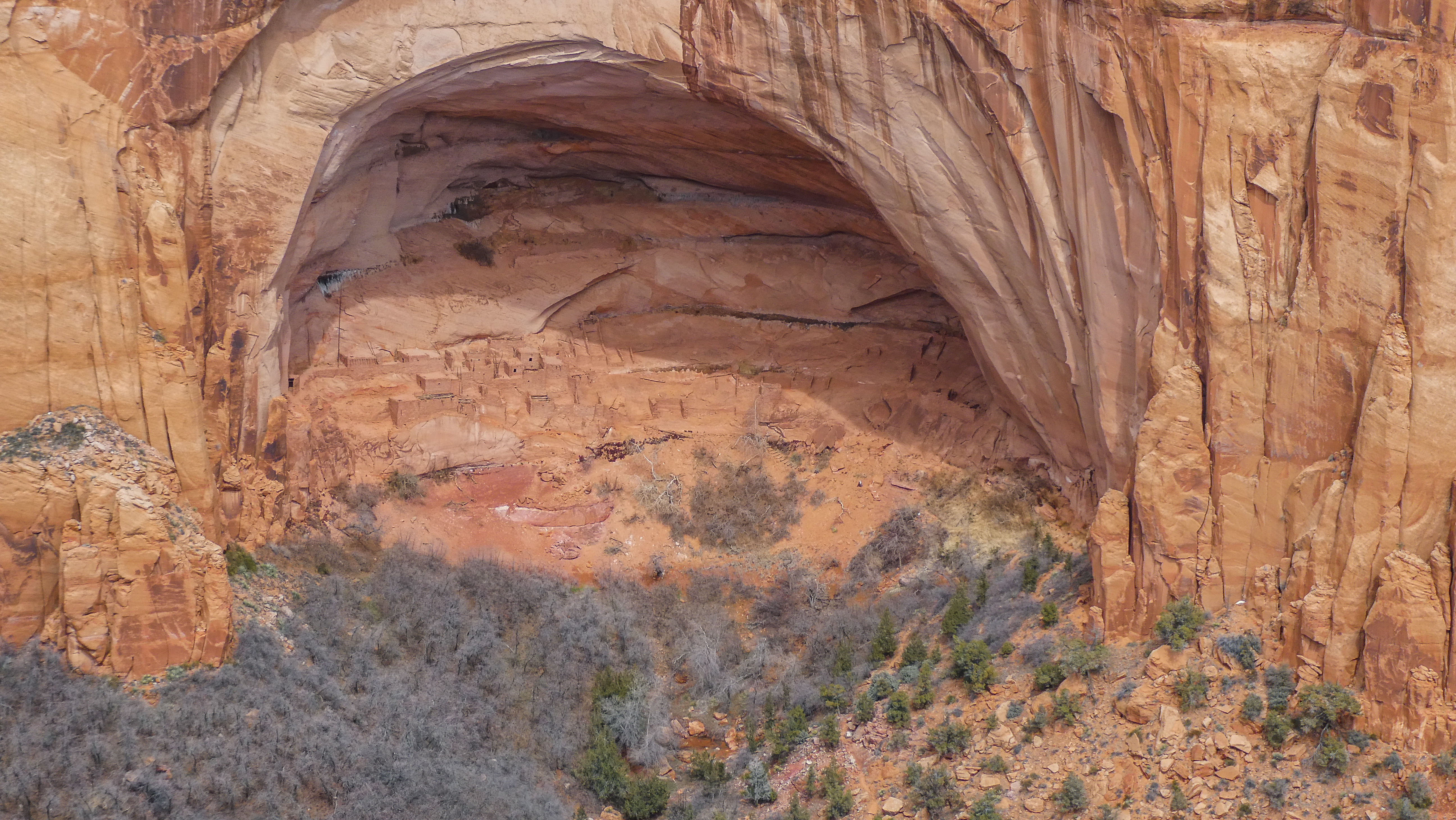
That's the niche in the wall where the pueblo lies. We were about 1/4 of a mile from the site. Scott
took a series of photos with his camera showing the pueblo that follows my text. |
This National Monument was established in 1909 to protect 3 well preserved Cliff dwellings of the Ancestral Pueblo People, which were occupied from around 1250 to 1300 AD. Like the other sites we have been visiting, the reasons for it's abandonment are debatable. The only trail open due to the snow was the Sandal Trail, 1.6 miles total, down to the view point to see the Betatakin "House Built on a Ledge, in Navajo" and then back up. The up part was tiring at that altitude but the views everywhere were worth it. We only wish that we had hats and gloves with us. We actually have gloves back at the RV and next time we will bring them. We tried to buy warm hats in Page but they were "out of season". Wow! The high here is 46 degrees!
 |
The trail was paved and could be
accessed by wheelchair (or
stroller) and free of snow. |
 |
| We loved the twisted trees that lined the path. |
After a brief stop in the warm Visitor's Center to eat our lunch, we drove back to Page. Tomorrow we'll be driving north again to Zion National Park. Till my next post, good-bye
 |
This series of photos shows ever closer views
of the pueblo. |
 |
There were 120 rooms at the time of the
abandonment. |
 |
The buildings are built of sandstone, mud mortar
and wood. |
 |
This is the smaller of the two pueblos that you
can see now at the Monument. The larger one
requires a 7 mile hike with a Ranger guide. |


No comments:
Post a Comment